A few years ago, when hopes to leverage technology to build a more humane “sharing” economy had not yet completely vanished, it was often believed that the most interesting policy experiments were to be found at the local level of cities, not states. One of those was the urban-planning concept of a 15-minute city, aiming to make any essential amenities such as schools and shops accessible within a 15-min walk or bike ride. Launched in Paris before receiving enthusiastic support worldwide, it was part of the current mayor’s latest re-election campaign.
Fast forward to today, and how actually far is Paris from the 15-min goal? Sarah J. Berkemer and I have endeavoured to answer this question in a just-published article (available in open access!) with three brilliant ENSAE students (Marie-Olive Thaury, Simon Genet and Léopold Maurice). We harness open map data from the large participatory project Open Street Map and geo-localized socio-economic data from official statistics (Insee) to fill this gap.
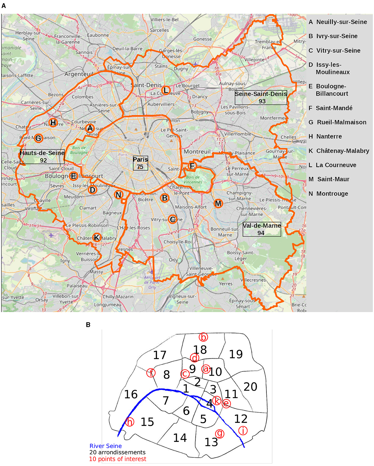
While the city of Paris is rather homogeneous, we show that it is nonetheless characterized by remarkable inequalities between a highly accessible city centre (though with some internal differences in terms of types of amenities) and a less equipped periphery, where lower-income neighborhoods are more often found. Heterogeneity increases if we consider Paris together with its immediate surroundings, the “Petite Couronne,” where large numbers of daily commuters and other users of city facilities live.
We find that this ambitious urban planning objective cannot be achieved without addressing existing socio-economic inequalities, and that especially in a big city like Paris, it cannot be confined within the narrow boundaries of the municipality itself, without also including the city’s immediate surroundings.
One reason why I am particularly proud of this work is that it demonstrates how far research-informed teaching can go. Most higher education is about familiarizing students with generally accepted and confirmed knowledge, without going beyond the state of the art. This is certainly important and in all cases a “safe” bet, but does not give students a sense of what it means to push the boundaries further. This project was an opportunity to do so. It gave students the role of researchers – our peers – letting them play the role in full and showing them all the back-office work that lies behind publications (from drafting to responding to reviews and copy-editing), and that is (too) often occluded from students’ view. There’s probably more to experiment around this model.
To read the full article: Thaury M.-O., Genet S., Maurice L., Tubaro P. & Berkemer S.J., 2024, ‘City composition and accessibility statistics in and around Paris’, Frontiers in Big Data, 7, DOI=10.3389/fdata.2024.1354007
